
Destination: Driftwood Depot & Darb Lake [cabin]
(Click Map to Enlarge)
Route Briefing
- This Scenery is for "Return to Misty Moorings" only.
- Suggested Altitude: See Altitude at each leg.
- Landing zone is: Water - Freezes in Winter
- GPS for destination: N56 33.38 W126 10.58
- Distance approximately: 106 Miles
- Download PRINT-ABLE copy HERE
- Flight-Seeing Flight Plan & Map HERE
- Scenery Needed: Darb Lake and Driftwood Depot

Darb Lake & Driftwood Depot
NOTAM: You will need 2 sceneries for this trip, Darb Lake and Driftwood Depot, both can be found at RTMM/Scenery.
This is an interesting VFR Flight. You will first be following a lake, then a railroad, then a river, then a compass across a faceless high plateau expanse. There are pictures and maps of critical turns. This is an interesting VFR flight ... remember you are flying at some altitude, so weather can be an important factor.
After we take off from Takla Narrows, we will first stop at Driftwood Depot where we will look around, then take off again following the railroad. With the instructions in the flight plan, you will eventually find Darb Lake Cabin ... far out in the wilderness ahead.
People read books about building a cabin and living in remote regions but have no idea what it takes. People come up to Alaska and actually complain about the lack of fast food restaurants or about the fact they have to drive a day to get to the nearest Wal-mart. These are the same people who go up there and stop dead in the center of the highway to take a picture of a bear or walk up to a cow moose and her baby to get a better look. Young eco-hipsters move up there thinking that living in a small town on a road system, peeing in an outhouse, getting drunk at bonfire parties every night is "living" in the wild but not one of them would survive one month at a true remote homestead. Living remote is not one long camping trip. It is the type of lifestyle that can cost you your life. In a Oh-My-God I'm-Gonna-Die-Alone-In-The-Woods kind of way.
This cabin property is located in the farthest North East reaches of the Pacific Fjords coverage area. The closest settlement is Takla Narrows. If you want isolation and seclusion, this is the spot.
WaveTop VFR Plan
FROM : Tekla Narrows (CBD5)
TO: Driftwood Depot and Darb Lake [Cabin]
Before you take off, be sure to visit the little community of Tekla Narrows, complete with pier and boat! Remember, you are over 2200 feet in altitude in this area. (So use a radio altitude of 1200 feet.) Your first altitude setting should be 3400 feet!
Leg: Takla Narrows to Takla Landing
Initial Course: 309 (Follow Takla Lake)
Leg Distance: 21 Miles
Leg Altitude: 3400 feet (1200 Radio Altitude)
Fly a heading up Takla Lake, on an approximate 309 heading. Just fly the middle of the lake to Takla Landing which will show up on your starboard shore. Takla Landing is about 20 miles ahead. (If you are flying in winter, the lake will be frozen. The altitude of the lake is at 2266).
- Takla Lake is the fifth largest natural lake in British Columbia, Canada. It is a deep fjord-like lake with the Swannell Ranges to the east, the Driftwood River flowing into it from the north, and the Middle River draining it. It is the terminus of the early Stuart-Takla sockeye salmon run, and noted for its large rainbow trout, lake trout and Dolly Varden. The peninsula is the home of Mount Blanchet Provincial Park. Also on the peninsula is a herd of collared woodland caribou, and the winter range of grizzly bears. Two special features are Takla Lake Marine Park, and an Ecological Reserve on the peninsula, a stand of very northerly Douglas Fir. Takla Lake is also the origin of both of Canada's national airlines, both Russ Baker and Grant McConachie running bush plane routes out of Takla Lake. It is a popular canoe route from the top end down to Fort St. James.
- Takla Landing, also known as McLaing Landing is an unincorporated locality and former steamboat landing on the east side of Takla Lake[1] in the Omineca Country of the Central Interior of British Columbia, Canada. In the days of the Omineca Gold Rush, Takla Landing was a port for steamboats connecting trails from Hazelton, British Columbia via Babine Lake to trails leading from Takla Landing eastwards to the area of the gold strikes in the lower Omineca River.
Leg: Takla Landing to Bulkley House
Initial Course: 309
Leg Distance: 16.7
Leg Altitude:3400
After you pass Takla Landing, you will fly over Red Bluff and White Bluff, two small land masses that jut out from the starboard shore. Continue to fly up the lake until it ends. That will be Bulkley House.
Leg: Bulkley House to Driftwood Depot
Initial Course: 297
Leg Distance: 9.4 Miles
Leg Altitude: 3700

Set your altitude to 3700 feet. Driftwood Depot will come up about 9 miles ahead. After you leave the lake, look for a railroad line to port. Follow the railroad to Driftwood Depot.
It is recommended you land and look around at this amazing scenery location Brad Allen has built. This is the depot for the railroad, and we will be following the railroad when we leave Driftwood Depot. The airstrip is dirt and you will becoming to it almost on the runway heading. The altitude of the runway is 2382 feet. Adjust landing configuration and course accordingly when it comes into view.
Leg: Driftwood Depot to Sustut River Turn
Initial Course: 303
Leg Distance: 33 Miles
Leg Altitude: 3800
Set your altitude for 3800 feet on this leg. When you leave the depot come to a heading of 303, you will see the railroad below. Follow the railroad for 33 miles to the Sustut River. On this leg you will pass by Bear Lake and see the railroad running along its starboard shore. The railroad curves here and there to avoid ridges and bluffs, follow the railroad and maintain your altitude.
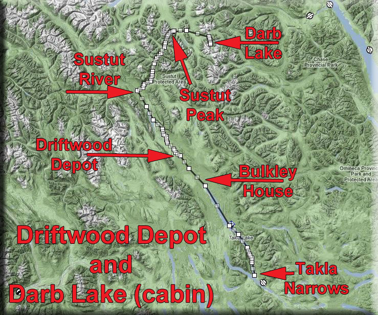
About 5 miles past Bear Lake, you will see an open, non-forested area ahead. The Sustut River flows from starboard down the valley you will see there. The river has cut some deep ravines in the landscape, look for the ravines and turn up the Sustut River Valley. Leave the railroad to port and change your heading to 038.
Gordon Lightfoot's Railroad Trilogy - Listen and Fly
- While we are flying, a little history about railroads in Canada. The first Canadian railway, the Champlain and St. Lawrence Railroad, was opened in 1836 outside of Montreal, a seasonal portage railway to connect river traffic. It was followed by the Albion Railway in Stellarton, Nova Scotia in 1840, a collier railway connecting coal mines to a seaport.The Albion Railway's Samson locomotive, the oldest surviving locomotive in Canada. Heavy expansion of the rail system did not get under way until the Guarantee Act of 1849 that guaranteed bond returns on all railways over 75 miles. This led to rapid expansion of railway in the Canadas, sometimes excessive growth as uneconomic lines were built since the government guaranteed profits.
- This proved disastrous for government finances, however, and the Canadas were all but bankrupted by the subsidies. The largest rail project of this period was also a disaster. The Grand Trunk Railway linking Montreal to Sarnia was finished in 1860, but was vastly mired in debt. In exchange for bailing out the company the government escaped its guarantee on the railway bonds. Canadian confederation was in part brought about by the railways. The local governments had all but emptied their treasuries building railways, and a new and more stable method of financing them was required. It was also believed that union would allow for the needed construction of railroads linking British North America. The Maritimes joined largely because of promises to build the Intercolonial Railway, and British Columbia only because of a promise to build a transcontinental railroad.
- The railway to the Pacific, the Canadian Pacific Railway, was financed by private funds and through massive land grants in the Canadian prairies, much of it of little value until the railway arrived, $25 million in cash and a guaranteed monopoly. The railway, an engineering marvel that was then the longest in the world, was completed in 1885 to great fanfare.
- The booming Canadian economy after 1900 led to plans to build two new transcontinental railways. The Canadian Northern, a successful system covering the northern part of the prairies, and the Grand Trunk (through its Grand Trunk Pacific subsidiary) both launched ambitious plans to expand. The government at first encouraged the two to come to some arrangement and only have one new line, but in the end no agreement was made and the government supported the expansion of both lines. The federal government itself built the National Transcontinental Railway, a line from Moncton to Winnipeg, passing through the vast and uninhabited hinterland of the Canadian Shield.
- This aggressive expansion proved disastrous when immigration and supplies of capital all but disappeared with the outbreak of the First World War. The Canadian Northern, Grand Trunk Pacific, and Grand Trunk were nationalized by the federal government, which absorbed the debt of over two billion dollars. All three railways, along with the Canadian Government Railways (formed by the Intercolonial, National Transcontinental, and several smaller lines) were then merged into the Canadian National Railways in 1923. The years after the First World War saw only moderate expansion of the rail network and the age of the great railways were over in Canada. The automobile provided strong competition by the 1920s, and after the Second World War most passenger service was lost to airlines. During the post-war period several large resource lines were opened in Quebec, Labrador, and British Columbia – several of which are not directly connected to the main North American network.
Leg: Sustut River to Sustut Peak Turn
Initial Course: 038 (following river and valley)
Leg Distance: 24
Leg Altitude:
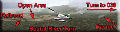
Turn to 038 and begin to follow the Sustut River. About 5 miles ahead, there will be a branch off to port, go to starboard and continue to follow the river. A few miles ahead, another branch of the river will go off to port, continue to follow the starboard branch.
5 Miles beyond this, you will see Sustut Peak coming up to starboard. you are going to fly around the base of that peak coming to a new heading.
Leg: Sustut Peak Turn to Johnson Lake
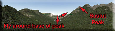
Initial Course: 062 (see map below)
Leg Distance: 13 Miles
Leg Altitude: 5500
Set altitude for 5500. You will be flying over a high plateau. Check the map carefully above. As you curve around the peak, you will be wanting to come to a heading of 062 for 5 miles until you are between the peaks there and over the river. That is a course correction point where you will alter your heading to 085 for 8 miles which should put you over Johnson Lake.

Reduce altitude to 5100 after the rise ahead of Johnson Lake. Put your aircraft into landing position before Johnson Lake. You will be taking a sharp turn to port and landing at Darb lake.
Leg: Johnson Lake to Darb Lake
Initial Course: 142
Leg Distance: 3 Miles
Leg Altitude: 5100 to lake level at 4826

As you cross Johnson Lake, look for the sharp peaked mountain and fly to the starboard of that, the lake is there 3 miles ached. Your altitude of 5100 feet is a good landing height for this lake. The cabin is at the far end of the lake. Safely land.
Welcome to the Darb Lake Cabin!
Doug Linn
Charter Manager
Misty Moorings, Inc
contact@mistymoorings.com
(Created 07.09.2012)
Copyright Return to Misty Moorings 2012